
MAPS OF THE GEORGETOWN DIVIDE
1865 TO THE PRESENT
Georgetown Divide Maps El Dorado County Eldorado National Forest California
As a help to others doing research, enjoy the following original El Dorado County and Eldorado National Forest original survey plats for townships on the Georgetown Divide in pdf format:
King Fire September/October 2014 U2 Photo Map of the Fire
King Fire September/October 2014 Progression Map of the Fire
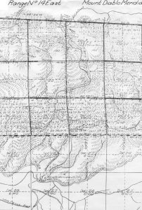
Township 12N R 14E Mount Diablo Meridan Union Valley
Township 12N R 15E Mount Diablo Meridan Upper Bassi Ranch
Township 13N R 14E Mount Diablo Meridian Top Half Gerle Creek, Airport Flats, AE Brown Ranch’s Francis Cow Camp, Jacobsen Dairy
Township 13N R 14E Mount Diablo Meridian Bottom Half South Fork Mill, Ditch Camp
Township 13N R 1`5E Mount Diablo Meridian Loon Lake
Township 13N R 15E Mount Diablo Meridian Eastern North South segment on border of Section Loon Lake
Township 14N R 14E Mount Diablo Meridian Bunker Hill, Murry Camp, Dellar Cabin, Gerle’s Ranch, Road to Bennett Range
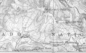
Township 14N R 15E Mount Diablo Meridian McKinstry or Bennet Lake, McKinstry Peak, Jerrett peak, Bugle Lake, Wentworth Springs
Township 14N R 16E Mount Diablo Meridian Rubicon Springs
G. M. Wheeler Atlas Sheet 47 B, D, E Calif, Nev 1876/79 After clicking on the link to the left scroll down and click on the thumbnail of the map to pull this map up from the David Runsey Collection.
G. M. Wheeler Atlas Sheet 56B, Parts of Eastern California and Nevada 1883
Col John C Fremont Map of Oregon and Upper California and the West 1848 showing his various expeditions to and from California

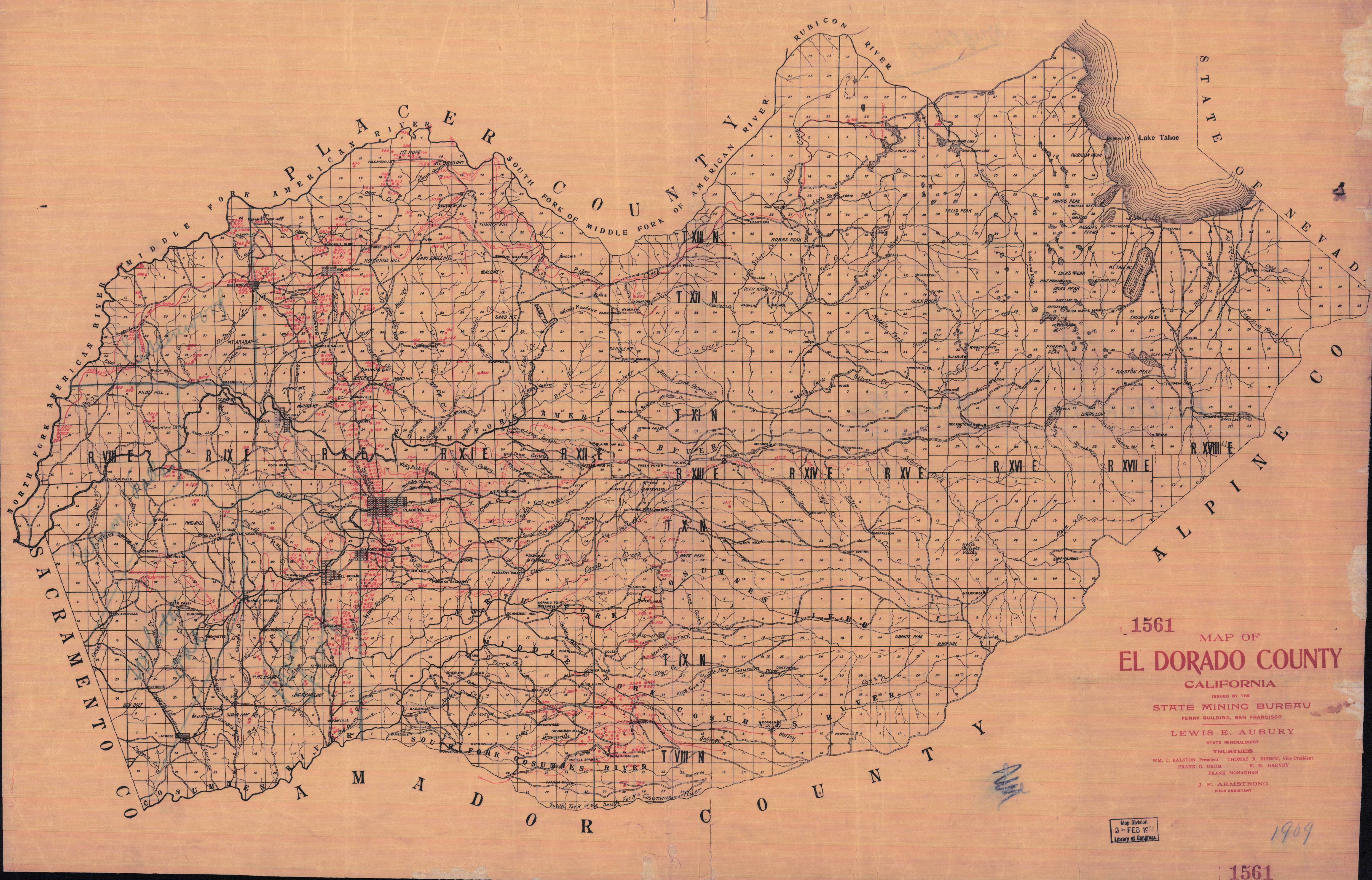
Map of El Dorado County, April 1902 showing all the known mines and claims including mineral springs issued by the California State Mining Bureau, Ferry Building, San Francisco-This copy was kindly donated for display here by Karl Stewart of Washington, California. This copy was originally obtained from the Library of Congress in 1938…..Many thanks to Karl for this donation to the overall historical record for early El Dorado County and Eldorado National Forest. He also provided the copy of the below Register of Mines and Minerals which goes with the map and is the way to determine all the individual mines annotated on the above map in red with a assigned number. Of great interest is the review of the mineral springs at Wentworth and Rubicon. Both were reported to flow 500 gallons a day. The report goes on to provide a full chemical analysis of each mineral spring and marks both in red on the map above.
Register of Mines and Minerals El Dorado County California, April 1902-18pages in PDF format-Thanks to Karl Stewart for donating the copy of this Register of Mines
This copy was donated by Chief Bill Holmes CalFire El Dorado County and of Gerle Creek Summer Home Tract. Lint Brown, the author of “Sixteen Summers…..” kindly worked his magic on the original scanned copy, improving the image and re-creating it in a size more conducive to the web page and downloading. Many thanks to both Bill and Lint……………..
The map back of the Eldorado National Forest Map of 1916….A full Copy This copy is the back of the map donated by Chief Bill Homes and created by Lint Brown
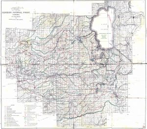
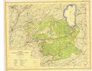
1931 Eldorado National Forest Map
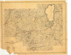
1943A Eldorado National Forest Map
1943B Eldorado National Forest Map
Eldorado National Forest Map of 1949-full copy-This copy donated by Chief Bill Holmes CalFire El Dorado County and of Gerle Creek Summer Home Tract

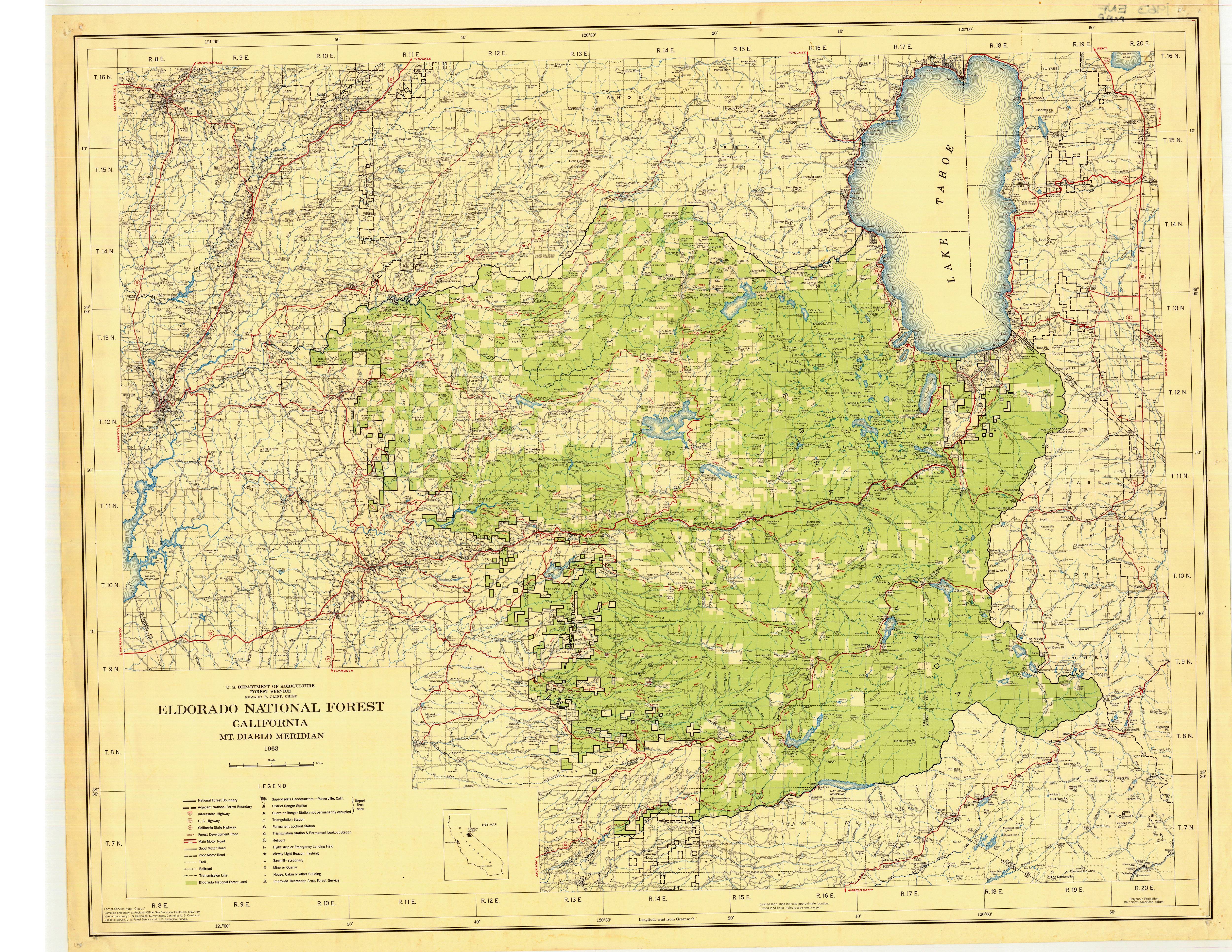
Eldorado National Forest Map of 1963-Full copy-This copy donated by Chief Bill Holmes, CalFire El Dorado County and of Gerle Creek Summer Home Tract
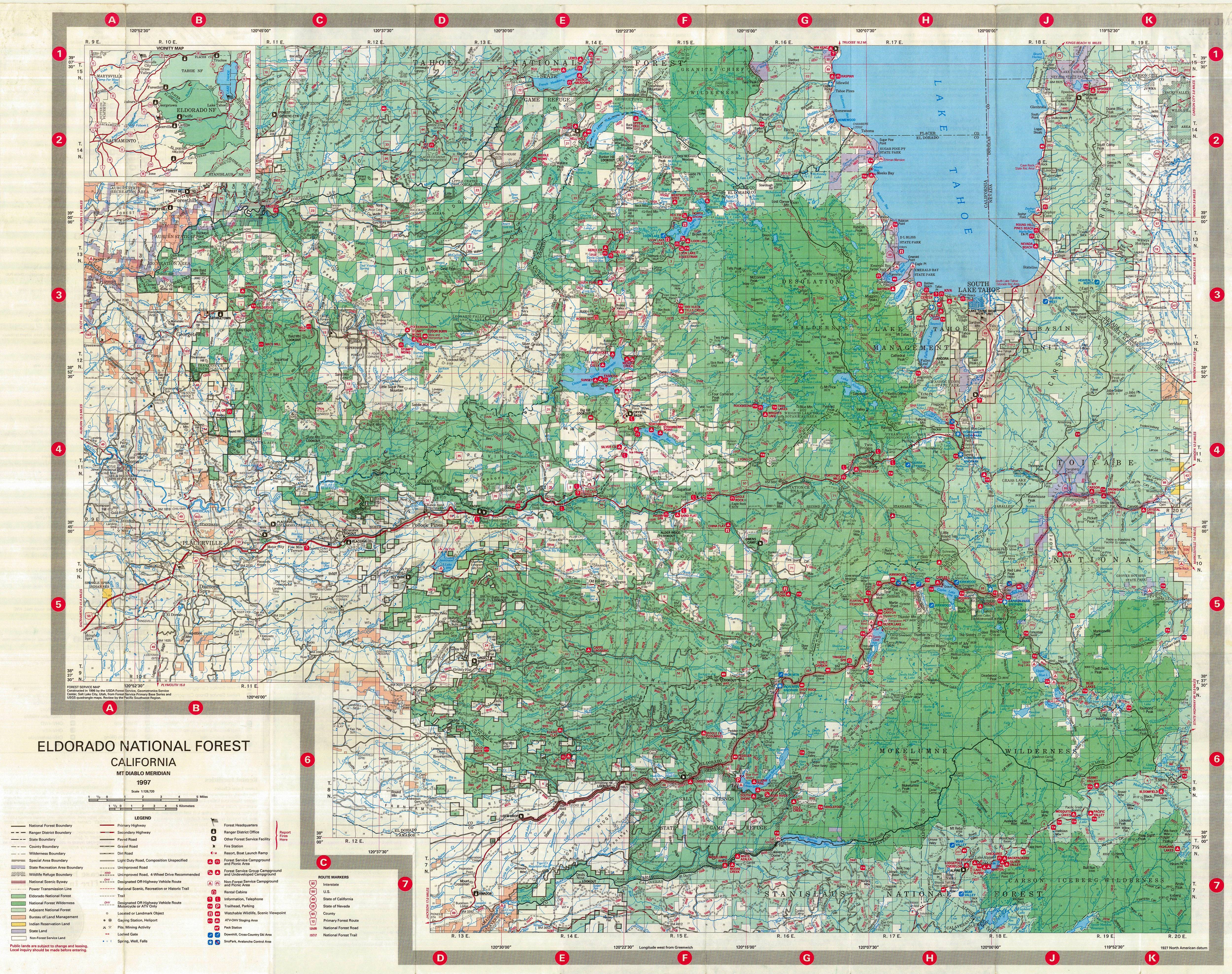
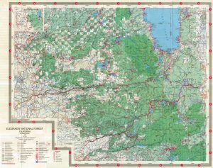
Eldorado National Forest Map of 1997-Full copy-This copy donated by Chief Bill Holmes, CalFire El Dorado County and of Gerle Creek Summer Home Tract
Ranch holdings in Union Valley 1959
Michigan-California Lumber Company Tree Farm Map of Properties-1960s
Gerle Creek Loon Lake Fish and Stream use Map and Report 1976-Update of 1956, 1968 and 1973 Report on the Fisheries of these water resources.
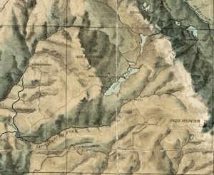
Some Reservoir Sites in the the Sierra Nevada, California F>A> Johnson December 1950-Good review of all the Reservoir sites and the plans and background on why they were selected circa 1950
The following are a collection of a number of old, historic copies of maps from 1865 to present day covering various areas within the Georgetown Divide and more specifically the Crystal Basin section of Eldorado National Forest and El Dorado County, California.
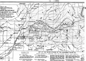
1. Amos Bowman Map of the Georgetown Divide prepared as part of a formal company report for the California Water Company, San Francisco, Ca in 1873. As you look closely, you will see only a few named major landmarks including Orelli’s on Robbs Meadow, McKinstry Mountain, Gurley’s or correctly Gerle’s etc….
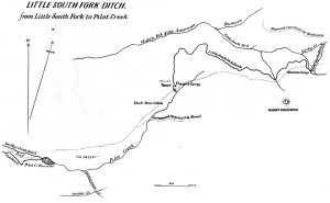
2. The following map was another Amos Bowman drawn map included in his formal report prepared for the Board of Directors on the holdings of the California Water Company, San Francisco, Ca in year 1874. This is a drawing showing the original ditch as built in 1874 from a spot at the upper end of current Gerle Lake at the diversion dam, which diverted water from Gerle Creek to what is now called the South Fork Mill, or the Ditch Camp area on the South Fork of the Rubicon River… for further diversion to Georgetown….later between 1874 and 1880, the California Water Company built the water powered sawmill at Hanna’s Camp inorder to supply lumber to repair and build the many wooden flumes which made up the water connection from Gerle Creek all the way to Georgetown….
3 This map was created for the formal report to the Board of Directors on the holdings of the California Water Company of San Francisco, Ca in 1880. Of particular interest was the Company’s desire to consider a railroad to Lake Tahoe which would go along the Eastern side of Loon Lake
4. The following is a section of the original Survey Plat of the California Survey (USGS) of the Wentworth Springs, Ca area, circa about 1882, slightly after the resort was built by Wentworth and Winslow in the 1880-1881. It also shows Bugle Lake.

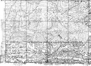
5. This is the original Survey Plat of the area of Gerle’s House, or Gerle’s Ranch…what is commonly now know as Lawyer’s Cow Camp on Gerle Creek about 3 miles before Wentworth Springs. This plat also shows Bunker Lake, as well as the Road to Bennett’s Range or ranch at McKinstry Lake….as well as showing Deller’s cabin on the East side of Bunker Hill in the meadow……..parts of this survey plat were completed in the 1860s while the final piece of survey work was done in 1880s, forming the basis for all future maps of this area. The rather interesting aspect of original Survey Plats was the detail the surveyors went to and all the annotations of individual property owners and names known at the time.
6. This is the original Survey Plat of the area from Jacobsens Ranch including his house and pasture area on Gerle Creek, the original Georgetown-Lake Tahoe road from Jacobsens. It shows the Francis Ranch, Airport Flats area where the road clearly fords Gerle Creek at Airport Flats and again fords Gerle Creek at Francis. It shows the AE Brown ranch house down the Gerle Creek Diversion Dam or ditch keeper road from Airport Flats as well as the AE Brown cabin in Long Meadow. Further to the bottom of the map it clearly shows the California Water Company Mill at the South Fork of Rubicon River and Gerle Creek where the ditch diverting water out of Gerle Creek ends up.
7. 1865-1880 USGS Survey Plat of Rubicon Springs area
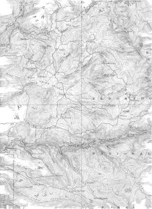
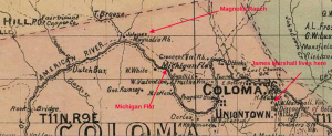
8. This is the original USGS Map of the Georgetown Divide area, published in 1895 and reissued in 1932. This map was the first formal result of all the original survey plats done for each and every section in California beginning in the 1860s and finally certified in 1895. This map is particularly interesting as it shows the original family names for certain famous landmarks in the area which are still significant today, including Stone Celler which is designated with the Forni family name as they owned the property at this time…..Hanna’s Camp identified as “Sawmill” on this map…..Orellis which identifies the family who owned the ranch immediately next to the current Robb’s Resort……Fillippini’s…..the original homesteaders and builders of the famous ranch which in the last 50 years has been referred to as Van Vleck Ranch…..Mr Fillippini’s more common name was “Bill Tell” for which Tell’s Peak and Tell’s Creek were named, an early Italian Swiss 49er family who lived down in the Georgetown area and summered on this beautiful ranch. Unfortunately, it burned in 1992 as a result of a chimney fire. There are even more famous names on this map, but maybe no more famous than the name “Moores” which was the original name for Riverton on the South Fork of the American River and so marked today by a historical marker, as well as the “Georgetown Junction” which was basically Kyburtz……..these two 1895 USGS Maps were kindly donated to me by Judge Wil Johnson out of his own collection of historic information on Wentworth Springs.
9. The following map is a continuation of the 1895 USGS map of the Georgetown Divide area showing Wentworth Springs, Gerle’s and Jacobsens on the Gerle Creek.
10. This map is a further continuation of the 1895 USGS Map of the Georgetown Divide area………
11. 1915 Map of the Georgetown Divide by George W. James
12. The 1916 USFS map(North Half) of the Eldorado National Forest…………..edited copy by Lint Brown……Original copy donated by Chief Bill Holmes of GCSHT
12a. The 1916 USFS map of Eldorado National Forest (South Half)……………edited copy by Lint Brown….Original copy donated by Chief Bill Holmes of GCSHT.
12b. The 1931 USFS map of Eldorado National Forest
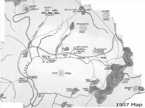
13. 1937 hand drawn map by Judge Wil Johnson’s father of the Loon Lake, Wentworth Springs, Gerle Creek, Rubicon Springs area of the Eldorado National Forest. Of great interest is the existence of the US Forest Service Ranger station at the original Wentworth Springs Forest Service Camp Ground, about 1 mile East of Wentworth Springs on the road to Lake Tahoe. This ranger station was similar to the ranger station at Schlein’s Ranger Station on the way into Loon Lake. Lastly, McKinstry Peak is depicted in the wrong place….the peak noted as McKinstry is really Jerrett Peak. Jerrett Peak is really on the North side of the lake shown next to it which is Bugle Lake. Last correction is Jerrett Creek comes out of McKinstry Lake and not Bugle Lake.
13A. The 1943 USFS map of Eldorado National Forest
14. 1950 USFS Map of the Pacific District of the Eldorado National Forest
15. 1950 USFS Map of the Georgetown District of Eldorado National Forest
16. USFS Gerle Creek Summer Home Tract Map, dated 1953 These are the first series of maps done by the USGS post World War II.
17. 1953 USGS Map showing the Airport Flats, Gerle Creek Summer Home Tract area, the Gerle Creek Diversion Dam, Gerle Creek Ditch and the Ditch Camp at South Fork of the Rubicon River.
17. 1953 USGS Map of Eldorado National Forest
19. 1953 USGS Map of Eldorado National Forest
20. 1953 USGS Map of Eldorado National Forest
21. 1953 USGS Map of Eldorado National Forest
22. 1953 USGS Map of Eldorado National Forest
23. 1953 USGS Map of Eldorado National Forest
24. 1953 USGS Map of Eldorado National Forest
25. 1953 USGS Map showing the Lawyer Cow Camp or Gerle’s area of Gerle Creek, including Jacobsen’s, Murray Camp and Wentworth Springs.
26. 1953 USGS Map of Eldorado National Forest
27. 1953 USGS Map of Eldorado National Forest
28. 1953 USGS Map of Eldorado National Forest
29. 1962 Gerle Creek Dam survey map done of the area where the dam and lake was to be built by SMUD
30. 1964 Gerle Creek Summer Home Tract Map showing all lots and the layout of the new tract water system.
31. 1974 USFS Map of Eldorado National Forest
32. 1982 USFS Map of Eldorado National Forest
33. 1997 USFS Eldorado National Forest Map
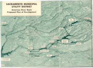
34. Sacramento Municipal Utility District American River Basin Proposed Plan of Development 1957 . As a note, the original plan for Sawmill Reservoir to be located at the confluence of Gerle Creek and the South Fork of the Rubicon Rivers was modified later in July of 1960(Sacramento Union, July 8, 1960), when due to budget constraints on the expense and length of the Robb’s Peak tunnel, they decided to shorten it by 5000 ft, saving a $1million dollars thereby creating the Gerle Creek Reservoir in its present location, while creating a small diversion dam on the South Fork of the Rubicon river up stream from the confluence of Gerle Creek. this change also required the building of a ditch to connect the outlet of the Loon Lake tunnel at Gerle Reservoir and the South Fork of the Rubicon River Diversion Dam.
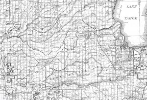
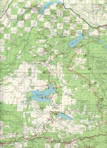
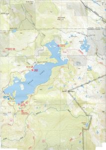
34. 2000 USFS Eldorado National Forest Desolation Valley Map showing the Loon Lake area……….
Georgetown Divide Maps El Dorado County Eldorado National Forest California